New Hampshire Nature Notes
by Eric Orff
The Day the Suncook River Flowed Upstream During The Great Mother’s Day Flood of 2006!
Thursday 05/18/2006
For much of the night and well into the day of Tuesday May 16, 2006 the Suncook River actually flowed upstream from the Old Mill Dam in Epsom, all during the highest flood in 100 years on the river. In fact the river flowed north in the opposite direction it had flowed since the Ice Age. Indeed, a half mile section of the Suncook River, immediately upstream of the Old Mill dam, drained during the great Mother’s Day flood of 2006.
A half mile upstream, a breach in the river’s historic banking was pulling the river into an entirely new channel, and literally would suck the old riverbed dry in less than 12 hours. Not only did the new channel suck dry the riverbed above the two dams situated at the head of a series of falls that coursed either side of Bear Island, but it turned two mile-long stretches of roiling flood waters on either side of the island to dry riverbeds as well. In less than a day, two and a half miles of the Suncook River simply disappeared, during a flood!
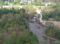
Local dam historian Al Bickford of Epsom, pegs the construction of the pair of dams, still in place at the island’s north end, at between 1870 and 1872. The NH Department of Environmental Services Dam Bureau names this dam, the Huckins Mill Dam. Their records show it was reconstructed in 1937 for a saw mill. This dam has 202 square miles of drainage area with an impounded surface area of 5 acres. The western section, closest to the old mill, is 98 feet wide with a maximum height of 13 feet. Most recently, in the 1980’s, the dam was converted to a hydro power unit for a short period. Then the mill site was converted into the Old Mill Restaurant, and is currently occupied by the Concord Elks Club.
But lets back up to see how quickly the complexion of the Suncook River changed from a meandering river in Epsom, save for the two sections of the river that bracketed Bear Island. In stead of meandering, this section of the river tumbled down a series of rapids and falls for most of the length of the mile-long island before rejoining as one at the confluence of the island’s tail. This created the best section of river for trout fishing in Epsom.
The river sweeps past my house about three miles downstream. For the first time in the twenty-six years I have lived overlooking the river it didn’t completely freeze last winter, at least by my house. The snow-less winter and dry spring conditions, that just over a week ago had the sign next to the Epsom Fire Department declaring “No Burning Permits Issued”, also practically put the river into a summer slumber stage.
All that changed with a deluge of rain starting most of the day Saturday. By evening my rain gauge measured 3 ½ inches. Our sleeping neighbor was stirring by nightfall. By Sunday morning the Flood Warning predictions, that seemed so senseless two days before, were looking more ominous by the hour. The river was rising rapidly. In fact I spent much of Mother’s Day helping a neighbor downriver from me sandbag the flood wall he built in 1988 to protect the lower level of his home which sets right at river’s edge. We hurriedly added a layer of sand bags on top of his three foot high wall.
As we worked through the afternoon, on the opposite side of the eight inch wide wall we were capping, the river was growing in power carrying whole trees and even a whole wall of a structure with cupboards still attached bobbed by at nearly eye level. The rapidly rising river rose to the top of the wall just as we finished one layer of sandbags. Then in what seemed like minutes the river won and pouring through and over the sandbags. I was soaking wet and exhausted.
By nightfall my rain gauge was full again to the 4 ½ inch level, bringing the total to 8 inches in two days. (We got two more inches before the end of the rain storm) And the once quiet river roared past my house in the darkness.
Monday morning I awoke to a totally different looking river. It was higher than I had ever seen it; the cornfield and meadow below my house were flooded and the river was filled with debris from parts of trees to bottles and unidentified building parts. The Suncook churned all this material in a boiling rage, and seemed to spit it right at me from a hundred yards away until the 90 degree bend yanked them from my view. It was awesome!
But not as awesome as what four locals would witness by late morning. Local farmer Bill Yeaton relayed to me the next day what he and three others including Ronnie Colby, Chris Paris and Peter Demers watched just as the Suncook River changed course in a matter of minutes by noon on that Monday May 15th.
By Bill’s description, the event of the century in Epsom was just underway when he arrived at the locally called Cutter’s Pit at the end of Rhodora Drive at about 11:00 AM on Monday. The Suncook had overflowed its bank a quarter mile above the access road to the pit, flowing through a wetland and boggy area along the edge of the old Suncook Railroad bed before converging on the access road and flowing into the pit. The flow was picking up dramatically by the minute according to Bill and was soon a raging flood. I then began to devour the bowels of the sand pit and ripped huge trees and house sized chunks of the pit quickly washing then down the newly formed river.. The river was relentless at tearing at the earth widening the trough to a hundred feet, then two hundred feet and more as the raging boiling flow gained momentum. Then the tongue began to devouring the sand to the north along the bed of the pit slicing off three hundred foot wide swaths at a time. Chomping the exposed sand pit as it marched northward within minutes creating a canyon like vision in the once flat sand pit bed.
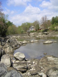
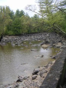
It was mid afternoon when the current owner of the old mill site, Bob Griggs, first noticed a change in the flow of water that had been pouring six feet high over the top of the dam at the Old Mill. A huge white pine tree, 60 feet in length, was forced mostly over the dam by the powerful flows on the far side of the dam. He noticed by midnight that only a small flow was pouring over the dam. When he last checked at 2:00am, the top of the dam was bare. The river was retreating upstream flowing away from the upstream side of the dam face! By mid morning the water level was two feet DOWN the front side of the dam – as the river continued to flow upstream. Below the dam the river was waterless, a few foot long rainbow trout were seen flapping in the few remaining pools. By day’s end the channel immediately above the dam was dropping even faster as its withdrawal hastened. By Wednesday morning it was nearly possible to walk across the river even above the dam. The growing vortex less than a half mile above the dam had swallowed all the flood waters. The Suncook River flowed upstream from the dam until it vanished from the nearly a half mile section to the breach. But the flood raged on in its new channel.
Click to see the Suncook River Changes Channel
Next Note
2006-05-23
A week and a day since the Suncook River changed course the river still runs chocolate.
